Induced earthquakes raise chances of damaging shaking in 2016: USGS
March 29, 2016 by Canadian Underwriter
Print this page Share
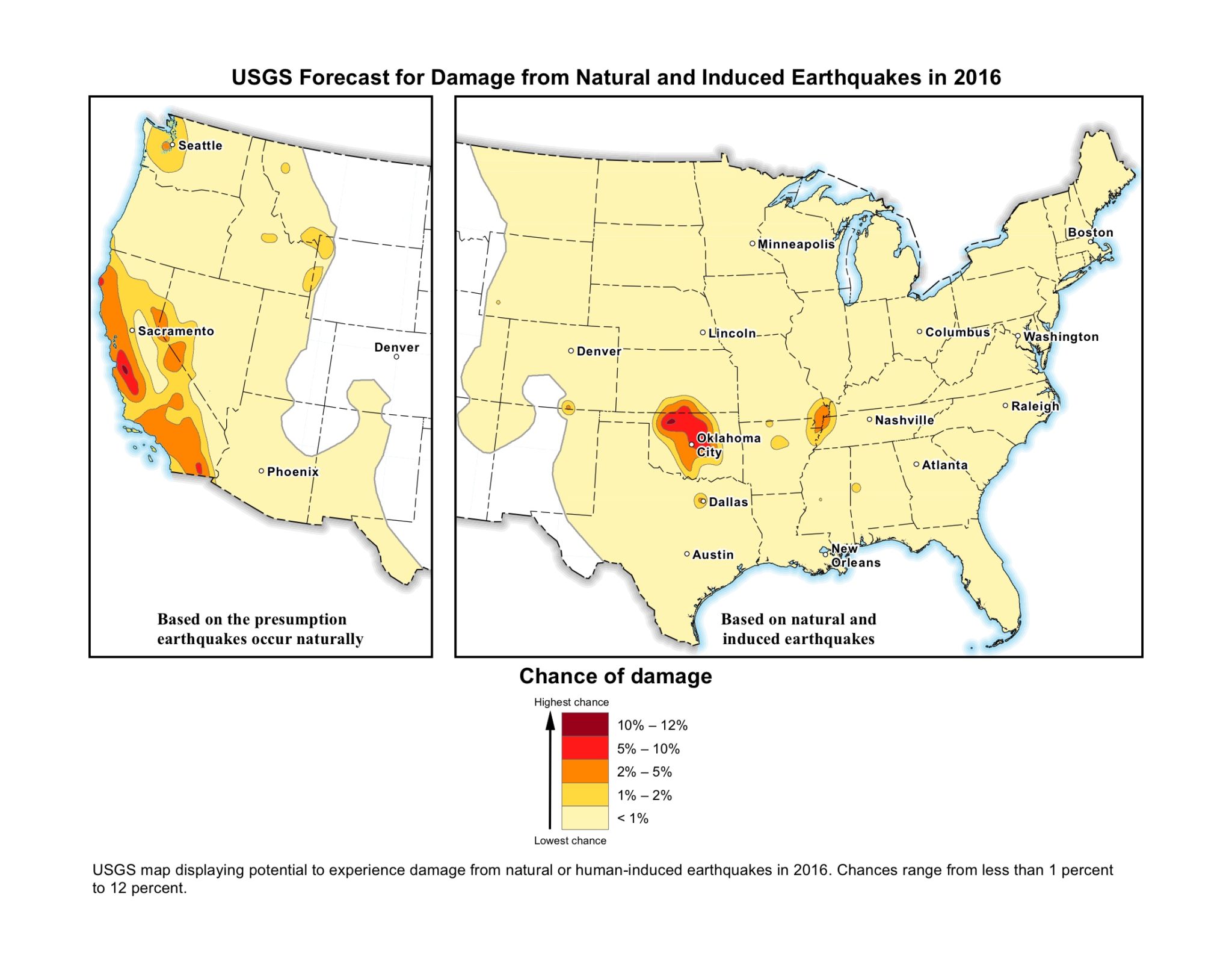
New maps identifying potential ground-shaking hazards from both human-induced and natural earthquakes show there is potential for damaging shaking from induced seismicity for about 7 million who people live and work in areas of central and eastern United States (CEUS), reports the U.S. Geological Survey (USGS).
“Within a few portions of the CEUS, the chance of damage from all types of earthquakes is similar to that of natural earthquakes in high-hazard areas of California,” notes a statement from the USGS, the only federal agency with responsibility for recording and reporting earthquake activity nationwide and assessing seismic hazard, which Monday announced the availability of the maps. (In the west, scientists categorized all earthquakes as natural.) [click image below to enlarge]
 The USGS explains that induced earthquakes are triggered by human activities, with wastewater disposal being the primary cause for recent events in many areas of the CEUS. Wastewater from oil and gas production operations can be disposed of by injecting it into deep underground wells, below aquifers that provide drinking water, the statement notes.
Serving as the USGS’s first one-year outlook for the nation’s earthquake hazards, the new hazard model estimates where, how often and how strongly earthquake ground shaking could occur in the U.S. during 2016. The map uses a 50-year forecast because that is the average lifetime of a building, and such information is essential to engineering design and the development of building codes (building code committees are still determining if it is appropriate to treat induced earthquakes in building code revisions).
The short one-year timeframe was chosen “because induced earthquake activity can increase or decrease with time and is subject to commercial and policy decisions that could change rapidly,” the USGS notes.
Mark Petersen, chief of the USGS National Seismic Hazard Mapping Project, points out that “by including human-induced events, our assessment of earthquake hazards has significantly increased in parts of the U.S.” In addition, the research “shows that much more of the nation faces a significant chance of having damaging earthquakes over the next year, whether natural or human-induced,” Peterson continues.
Overall, USGS scientists identified 21 areas with increased rates of induced seismicity associated with wastewater injection. “While most injection wells are not associated with earthquakes, some other wells have been implicated in published scientific studies, and many states are now regulating wastewater injection in order to limit earthquake hazards,” the statement notes. [click image below to enlarge]
 In the central U.S., the USGS reports there was an average of 24 earthquakes of magnitude 3.0 and larger per year between 1973 and 2008. “From 2009 to 2015, the rate steadily increased, averaging 318 per year and peaking in 2015 with 1,010 earthquakes. Through mid-March in 2016, there have been 226 earthquakes of magnitude 3.0 and larger in the central U.S. region,” the statement notes, adding “the largest earthquake located near several active injection wells was a magnitude 5.6 in 2011 near Prague, Oklahoma.”
The USGS map also shows earthquakes – both natural and induced – recorded from 1980 to 2015 in CEUS with a magnitude greater than or equal to 2.5.
The potential to experience damage from a natural or human-induced earthquake in 2016 ranges from less than 1% to 12%, the USGS reports. Listed from highest to lowest potential hazard, the most significant hazards from induced seismicity are in Oklahoma, Kansas, Texas, Colorado, New Mexico and Arkansas, with Oklahoma and Texas having the largest populations exposed to induced earthquakes.
Beyond documenting high shaking and damage in areas of the six states over the past five years, mostly from induced earthquakes, Peterson says the USGS’s Did You Feel It? website has archived tens of thousands of reports from the public who experienced shaking, including about 1,500 reports of strong shaking or damage.
“While there are some areas of induced earthquakes in the western U.S., they don’t significantly change the regional hazard level compared to the much more abundant natural earthquakes,” the USGS explains. “Therefore, scientists just considered the historical catalog in the western U.S. and did not separate natural from induced earthquakes.”
The USGS reports that current research indicates the maximum magnitudes of induced earthquakes may be lower than for natural earthquakes, but many scientists suggest induced earthquakes can trigger larger earthquakes on known or unknown faults.
“In the CEUS, there may be thousands of faults that could rupture in a large earthquake. Induced earthquakes also tend to exhibit swarm-like behaviour with more numerous and smaller earthquakes at shallower depths. These factors were taken into account in the analysis,” the statement adds.
“Testing these maps after a year will be important in validating and improving the models,” Petersen suggests in the statement.
The new report “can be used by both government officials to make more informed decisions and by emergency response personnel to assess vulnerability and provide safety information to those who are in potential danger,” the USGS suggests. “Engineers can use this product to evaluate earthquake safety of buildings, bridges, pipelines and other important structures.”
Have your say: