Google offers look at fire damaged Fort McMurray neighbourhoods
May 14, 2016 by The Canadian Press
Print this page Share
Fort McMurray evacuees eager for a look at how their neighbourhoods fared during a recent forest fire have a new tool – Google.
The California-based Internet giant is offering a bird’s-eye view of the city taken from satellite imagery on May 5. It clearly shows which streets of the city suffered most from the fire, which destroyed 2,400 buildings.

“They happened to be on the right orbit and the right spot to capture these pictures,” said Christian Adams from Google’s crisis response team. [Visit: https://www.google.org/crisismap/2016-fort-mcmurray-fire]
 “They’re orbiting the Earth every day, so it wasn’t that big a surprise – a combination of the orbit and the clouds being out of the way that let us get these particular pictures.”
The site also contains information on shelters and traffic conditions.
Adams said the company has been able to spread the word about the site through its Google Now program, as well as through its public alerts program.
He said the company has no way to trace those who use the site, so can’t create a list for sale to advertisers.
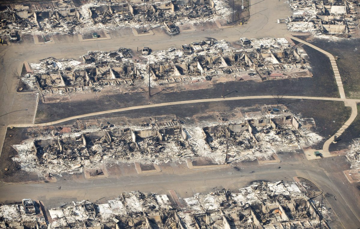
A devastated neighbourhood is shown in Fort McMurray, Alta., on Friday, May 13, 2016. THE CANADIAN PRESS/Jason Franson
“We don’t have any way of knowing that level of detail about people or anything about who accesses the site.”
Google first offered maps of disaster zones to help residents and responders after Hurricane Katrina, which tore through New Orleans in 2005.
Google Crisis Map is now tracking reported fires Alberta #ymmfirehttps://t.co/GhBO2kli9d pic.twitter.com/lRREAkJ9cJ
— Google Canada (@googlecanada) May 5, 2016
Our #FortMcMurray data's available under an open license & traceable on @openstreetmap https://t.co/uzEaoLL5kR pic.twitter.com/5e1uqzIfo1
— Planet (@planet) May 10, 2016
As fire rages in Alberta @WorldResources explores context & implications w. @globalforests: https://t.co/pYTBiQoWZa pic.twitter.com/aaN2379HTG
— Manish Bapna (@ManishBapnaNRDC) May 11, 2016
Before and after the #FortMacFire, 350 miles above Earth via @WIRED: https://t.co/kerQGYkQ9j pic.twitter.com/o2j4MnE9cr
— Maxar Technologies (@Maxar) May 10, 2016
Fire alerts from @NASA and #VIIRS satellites show up across #Canada https://t.co/haLgfV0OMm #wildfire pic.twitter.com/BVzdgqmaV6
— Global Forest Watch (@globalforests) May 9, 2016
Infrared satellite imagery reveals #FortMacFire damage via @TIME https://t.co/S8mE1N0GlS pic.twitter.com/ld5jFWyp4x
— Maxar Technologies (@Maxar) May 11, 2016
#ymmfire Another update to the estimated damage maps. Hoping official information will soon make this irrelevant. https://t.co/9kOAhfthBo
— mcmurraymap (@mcmurraymap1) May 9, 2016
.@mashable highlights more striking before and after imagery of the #fmmfire https://t.co/Jq1PZsreC5 pic.twitter.com/0JQS7gLMTE
— Maxar Technologies (@Maxar) May 11, 2016
WATCH: Looking back at a dramatic week in Fort McMurray with reporter @ReidFiest. #ymmfire #yeg #ymm https://t.co/uujj93Mclb
— Global Edmonton (@GlobalEdmonton) May 9, 2016
Print this page Share
It’s been removed. If you try to look at it now, a huge cloud is covering the entire fire area.