N.B. public safety department issues warning about ice jams, associated flooding
March 28, 2016 by Canadian Underwriter
Print this page Share
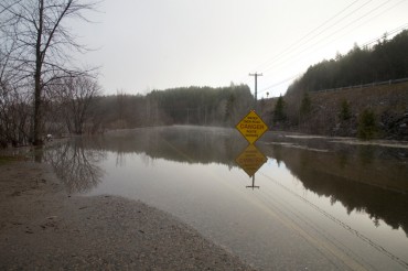
New Brunswick’s Department of Public Safety is warning about the potential for ice jams and associated flooding along the St. John River and other river systems in the province.
 The Department of Public Safety said in a bulletin on Monday that Environment Canada is forecasting “significant precipitation” across the province beginning this evening and continuing into Tuesday.
Water levels and flows are forecast to rise during the next 48 hours. Temperatures and rainfall are conducive to melting the snow pack and ice covers in all regions, the bulletin said, noting that ice may be moving along the St. John River and other river systems.
Ice jams may form as conditions are conducive to ice break-up and movement. Current ice jams include:
- Aroostook River: between Tinker and Masadis;
- Nashwaak River: between Stanley and Cross Creek, about two kilometres in length;
- St. John River: between Grand Falls and Nine Mile; and
- Southwest Miramichi River: Bloomfield Ridge at Norrad Bridge, extending 3.8 kilometres upstream.
“This is a continuously changing situation, and people are asked to be on the alert for ice movement and rising water levels,” the bulletin said.
On March 14, the department officially launched River Watch 2016, reminding New Brunswickers to be cautious around waterways and watch for any potential flooding in their communities. The program is a joint effort between the Department of Environment and Local Government and the Department of Public Safety’s Emergency Measures Organization. Other partners include NB Power and federal, provincial and state agencies involved in monitoring and forecasting the water flow in the province’s rivers and streams.
Have your say: